Bandwagon's Drones Thread
- Thread starter hodj
- Start date
You are using an out of date browser. It may not display this or other websites correctly.
You should upgrade or use an alternative browser.
You should upgrade or use an alternative browser.
- 26,192
- 71,142


I know this statement is a cliche, but I had a really good (and viable) invention idea late last night and was texting an electrical engineer I know about it. He really liked the idea and said that if I design & 3d print the parts, he'll handle the electronics for a prototype. I said I was going to buy Sketchup Pro and he said just get solidworks for $40. ")
- 26,192
- 71,142
FUCK.YES. This is what I've been wanting to build for 2 years.
I must have finally found the right person at ESRI, because this guy taught me how to do this in a 4 paragraph email. No one else that I ever talked to had any idea how to do something like this.
I must have finally found the right person at ESRI, because this guy taught me how to do this in a 4 paragraph email. No one else that I ever talked to had any idea how to do something like this.
15k sf lots? looks nice with the overlay, though i dislike porkchop lots (that one middle top) also not crazy about having road on either side of the lot... confuses people it is "15 xxx street or 15 yyy street since it "fronts" on both streets, though if there is an 8'+ drop from street to street you can have a nice setup for a rear driveway drive under garage.
bit of terracing to do? i am assuming its "ground, wall up,,, ground wall up etc for that bottom picture
bit of terracing to do? i am assuming its "ground, wall up,,, ground wall up etc for that bottom picture
- 26,192
- 71,142
Lot's of terracing on this one. It's on top of a (windy AF) hill. Really pretty area, though.15k sf lots? looks nice with the overlay, though i dislike porkchop lots (that one middle top) also not crazy about having road on either side of the lot... confuses people it is "15 xxx street or 15 yyy street since it "fronts" on both streets, though if there is an 8'+ drop from street to street you can have a nice setup for a rear driveway drive under garage.
bit of terracing to do? i am assuming its "ground, wall up,,, ground wall up etc for that bottom picture
vtour - 4234 | Westcliff Heights | Virtual tour generated by PBS
Vtour (site just north of the one in pictures above, but better weather) - 4391 | Summerview Terrace | Virtual tour generated by Panotour
- 26,192
- 71,142
Check this thing out,
L
Lenardo
Westcliff - Ops Dashboard
The trick is to use the "selector" to change what's displayed in the panels on the right.

Westcliff - Ops Dashboard
The trick is to use the "selector" to change what's displayed in the panels on the right.
- 26,192
- 71,142
Just some ground photos from another solar project. Large site, we got the "go" 3 days before the weather forecasts called for snow. I got about 60% of it flown before the snow hit.
Doing boundary here in these pictures, but I'll have to use USGS lidar for the rest of the contours. Planning to fill-in those contours in the spring at whatever location ends up being selected for a viable site.


Doing boundary here in these pictures, but I'll have to use USGS lidar for the rest of the contours. Planning to fill-in those contours in the spring at whatever location ends up being selected for a viable site.
- 26,192
- 71,142
We wouldn't hold it for anything anyways, but this one looks like it's been disturbed since it was placed. I just like finding these things. We had a couple of really good finds that trip. We found two section corners that were both about 3' down in creek beds. The magnetic locator doesn't work for shit around those rocks.cough don't forget to convert that elevation to the correct datum.....
Also, Skyward is using a small clip from one of my flights at CES today, around 4pm I guess if anyone wants to watch - CTA State of the Industry Address and IBM Keynote
Just a clip of the eBee in flight over some vineyards. I was hoping they'd stick with presenting the Portland schools project, but they only have a couple minutes to talk about the drone stuff.
i love finding those things too. i have old fema plans that show their benchmarks that we use constantly.
where i live there is one at the city hall front steps on the side. and then down the street @the library there is another one-both 1st order? (i forget) elevations vertically and 2nd order horizontally.
back ~25 years ago(early 90's)- before gps& most cellphones were around - we did several jobs for cell tower placements that required the state plane coords and elevations to within 15 feet horizontal and 5 feet vertical
we used a first order H/V usgs marker that was 3' under the ground (sucked digging it up) for our intial setup and the backsite was a first order horizontal benchmark/position - a church spire that was ~3 miles away...
and since we were on a hill, we did direct shots to the roof of the building where the tower was going to be placed that was ~4000 feet away. we had the rod man using binoc's so he could see me so he could move the rod around the roof enclosure so we could get the 4 corners for the antenna placement.
another one we did, we had to do a traverse and level loop that was 3 miles each way.
- 1
- 26,192
- 71,142
Haha, love it. I like listening to these guys talk about their old surveys they did before GPS/Cell phones/Robotic etc. Going to be a scary world being built when all you guys die off and no one knows how to do it with a pencil & paper anymore.
- 1

- 26,192
- 71,142
Boeing Autonomous Passenger Air Vehicle Completes First Flight - sUAS News - The Business of Drones
Boeing Autonomous Passenger Air Vehicle Completes First Flight
By
Press
-
23 January 2019
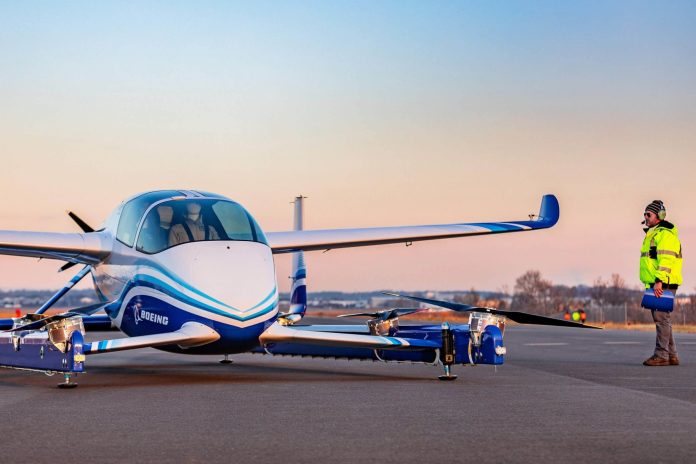
Boeing [NYSE: BA] yesterday successfully completed the first test flight of its autonomous passenger air vehicle (PAV) prototype in Manassas, Virginia. Boeing NeXt, which leads the company’s urban air mobility efforts, utilized Boeing subsidiary Aurora Flight Sciences to design and develop the electric vertical takeoff and landing (eVTOL) aircraft and will continue testing to advance the safety and reliability of on-demand autonomous air transportation.
The PAV prototype completed a controlled takeoff, hover and landing during the flight, which tested the vehicle’s autonomous functions and ground control systems. Future flights will test forward, wing-borne flight, as well as the transition phase between vertical and forward-flight modes. This transition phase is typically the most significant engineering challenge for any high-speed VTOL aircraft.
“In one year, we have progressed from a conceptual design to a flying prototype,” said Boeing Chief Technology Officer Greg Hyslop. “Boeing’s expertise and innovation have been critical in developing aviation as the world’s safest and most efficient form of transportation, and we will continue to lead with a safe, innovative and responsible approach to new mobility solutions.”
Powered by an electric propulsion system, the PAV prototype is designed for fully autonomous flight from takeoff to landing, with a range of up to 50 miles (80.47 kilometers). Measuring 30 feet (9.14 meters) long and 28 feet (8.53 meters) wide, its advanced airframe integrates the propulsion and wing systems to achieve efficient hover and forward flight.
“This is what revolution looks like, and it’s because of autonomy,” said John Langford, president and chief executive officer of Aurora Flight Sciences. “Certifiable autonomy is going to make quiet, clean and safe urban air mobility possible.”
The test flight represents the latest milestone for Boeing NeXt. The division works with regulatory agencies and industry partners to lead the responsible introduction of a new mobility ecosystem and ensure a future where autonomous and piloted air vehicles safely coexist. In addition to the PAV, the Boeing NeXt portfolio includes an unmanned fully electric cargo air vehicle (CAV) designed to transport up to 500 pounds (226.80 kilograms) and other urban, regional and global mobility platforms. The CAV completed its first indoor flight last year and will transition to outdoor flight testing in 2019.
“Boeing was there when the aviation industry was born and in our second century, we will unlock the potential of the urban air mobility market,” said Steve Nordlund, vice president and general manager of Boeing NeXt. “From building air vehicles to airspace integration, we will usher in a future of safe, low-stress mobility in cities and regions around the world.”
boeing.com.
- 1

- 26,192
- 71,142
FLIR Systems Awarded $39.6 Million Contract for Black Hornet Personal Reconnaissance Systems for U.S. Army Soldier Borne Sensor Program - sUAS News - The Business of Drones
FLIR Systems Awarded $39.6 Million Contract for Black Hornet Personal Reconnaissance Systems for U.S. Army Soldier Borne Sensor Program
By
Press
-
24 January 2019
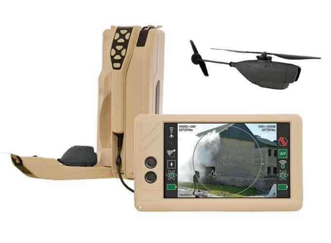
FLIR Systems, Inc. (NASDAQ: FLIR) has been awarded a $39.6 Million order to deliver FLIR Black Hornet Personal Reconnaissance Systems (PRS) in support of the United States (U.S.) Army. The highly capable nano-unmanned aerial vehicle (UAV) systems delivered under this contract will support platoon and small unit level surveillance and reconnaissance capabilities as part of the Soldier Borne Sensor (SBS) Program. The U.S. Army awarded in June 2018 the first SBS phase contract to FLIR for an initial batch of Black Hornet PRS. These systems are being delivered now to the U.S. Army for initial integration into the force.
“We are proud to be selected by the U.S. Army for the SBS Program of Record. This contract represents a significant milestone with the operational large-scale deployment of nano-UAVs into the world’s most powerful Army,” said Jim Cannon, President and CEO of FLIR Systems. “This contract is a major win for the newly established Unmanned Systems & Integrated Solutions business division at FLIR and demonstrates the strong and urgent demand for nano-UAV technology offered by FLIR. Protecting U.S. warfighters with our unmanned solutions is a key objective for FLIR.”
This contract expands the use of FLIR’s Black Hornet PRS for Army surveillance and reconnaissance programs. FLIR has delivered over 8,000 Black Hornet nano-UAVs around the world.
Due to the significantly increased demand for unmanned aerial system (UAS) support in the U.S., FLIR is expanding its UAS service and repairs center in Somerset, Kentucky. Deliveries will begin in early 2019. For more information about the FLIR Black Hornet PRS, please visit www.flir.com/blackhornet.
FLIR Systems Awarded $39.6 Million Contract for Black Hornet Personal Reconnaissance Systems for U.S. Army Soldier Borne Sensor Program
By
Press
-
24 January 2019
FLIR Systems, Inc. (NASDAQ: FLIR) has been awarded a $39.6 Million order to deliver FLIR Black Hornet Personal Reconnaissance Systems (PRS) in support of the United States (U.S.) Army. The highly capable nano-unmanned aerial vehicle (UAV) systems delivered under this contract will support platoon and small unit level surveillance and reconnaissance capabilities as part of the Soldier Borne Sensor (SBS) Program. The U.S. Army awarded in June 2018 the first SBS phase contract to FLIR for an initial batch of Black Hornet PRS. These systems are being delivered now to the U.S. Army for initial integration into the force.
“We are proud to be selected by the U.S. Army for the SBS Program of Record. This contract represents a significant milestone with the operational large-scale deployment of nano-UAVs into the world’s most powerful Army,” said Jim Cannon, President and CEO of FLIR Systems. “This contract is a major win for the newly established Unmanned Systems & Integrated Solutions business division at FLIR and demonstrates the strong and urgent demand for nano-UAV technology offered by FLIR. Protecting U.S. warfighters with our unmanned solutions is a key objective for FLIR.”
This contract expands the use of FLIR’s Black Hornet PRS for Army surveillance and reconnaissance programs. FLIR has delivered over 8,000 Black Hornet nano-UAVs around the world.
Due to the significantly increased demand for unmanned aerial system (UAS) support in the U.S., FLIR is expanding its UAS service and repairs center in Somerset, Kentucky. Deliveries will begin in early 2019. For more information about the FLIR Black Hornet PRS, please visit www.flir.com/blackhornet.
- 1
those look nice.
went to the MALSCE (Massachusetts association of land surveyors and civil engineers) convention this past weekend to attend some seminars and met the chair of the land surveying dept from Umaine and he LOVES drone work (uses an ebee plane drone with a 200 dollar camera-he gets verticals - flying at 400'- to under 2 hundredths of a foot-horizontal is ~0.2' or less. camera is @90 degrees down. what he does is fly the route using pix4d capture.
then after the initial route, he flies a circle around the site with the camera pointed in towards the center @45 degrees @400' as well.
after processing the pictures in pix4d, and generating the las & mosaic he then imports the data to Global Mapper - All-in-one GIS Software for doing all the other stuff like generating a topo/site/classifying the las data.
all the larger surveying firms in the area are heavily adopting GPS and lidar/drone photogrammetry - though drone work is ONLY done from ~november thru april (tree leaves) unless the drone has the lidar camera.
Last edited:
Share: