- 46,629
- 186,072


I have not. We use the black and white checlboard vinyl or plastic targets when we lay them out for geoterras lidar flights.Bandwagon
Hey man have you done and experimenting with highly reflective materials for ground control points?
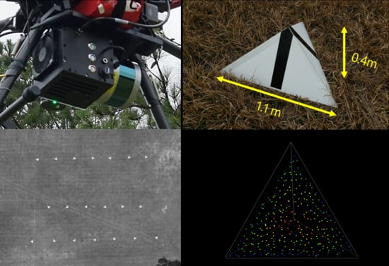
For this LiDAR drone, I am thinking we need to make better targets than what we were using for the photographic imagery drone process as these don't show as well in a LiDAR data set. Below is an example and as you can see it is very hard to see the black/white cross point in the LiDAR on a regular GCP that is for photogrammetry.
So far it is very impressive for $41k. We have been hitting our GCP and hard surfaces within the accuracy of the unit of around 0.33'.
View attachment 379316

No problem man I know how it is. I read an interesting paper about pyramid targets and we are discussing making our own similar.SorryVepil - I was just getting in the car when I typed up that response and meant to come back to it when I got back in the office.
We set targets for geoterra for their huge transmission line surveys and have always used the vinyl black/white triangle targets with a rebar in the center. I know that GeoCue has a few papers that describe ideal target material and placement. I haven't worked through it myself yet, but I remember reading stuff from GeoCue and USGS a few years ago and that's where I was planning to go read up after we get a LiDAR drone. I could phone-a-friend if needed, though. My go-to guy is a Photogrammetrist that ran a LiDAR/UAS mapping division for a large firm for quite a while, so I'm sure he could give me a 45 minute speech about it if needed.
Hey Vepil, what did this setup cost? I'm planning to buy an M300 L1/P1 this year, but it sounds like it's only going to improve our UAS mapping on sites with vegetation. The accuracy on hard surfaces is actually worse than photogrammetry (even with the 20mp Phantom 4 Pro camera).
Thought I would let ya know we purchased a LiDAR unit for our drone, should be in next week. Couple engineering/survey companies around GA have the same one so we felt comfortable in buying it and having some other support local than one no one was using. We went with Rock Robotic R2A unit for our M210. We knew we could get management to sign off on a unit but not a new M300 and a LiDAR unit. This one we can at least change the mounting system if we ever upgrade the drone.
Once I have some sample data sets I will let ya know what I think. So far I know one guy with this setup and he loves the data he gets from it.

ROCK Robotic
www.rockrobotic.com

 rapidlasso.com
A tragic end to a beautiful love.
Posted on September 11, 2021 by martin isenburg
I met Charm in January 2013 on my first big project after starting LAStools. She was one of the staff members of the DREAM LiDAR team that I was training on my software. She would eventually became a mentor herself and teach LAStools to other scientists across the Philippines. Over the years we became friends and when the LiDAR project completed in Cebu 2017, we started a romantic relationship. We had many amazing adventures exploring the many beautiful islands of the Philippines and other parts of Asia. In October 2019, Charm’s PhD move to Ireland brought our relationship to a new phase. During our Christmas road trip in Ireland our love and commitment levels were peaking. It was then that I decided to propose to her in late 2020. I was planning a surprise trip to Apo Reef hoping to ask her to marry me on top of the little white light house, where we it all began.
Suddenly the pandemic hit and trapped me far from Charm in Costa Rica. The virus stress triggered my long dormant bipolar condition into a manic episode. Alone and under lockdown in small village far from friends and family there was nothing that could stop my mania. It spun out of control and lasted about a year. Charm suffered for many months seeing my manic alter-ego doing crazy things and eventually decided to give up on our relationship. I cannot continue life, knowing that it was my very own brain that – completely out of the blue – destroyed our beautiful love story that had grown so strong over 8 years of mutual respect, trust and responsibility.
I am in a place now where my mania cannot hurt the people I love. I am sorry for all the pain I caused.
New Delhi, India 2017
On top of Apo Reef Light House, 2017
Charm’s birthday trip to Vietnam, 2017

 thedebrief.org


Professional. Yes I've used NVIDIA Jetson. I have lots of opinions on lidar vs stereo vs mono cam vs stereo cam.Tuco you do autonomous systems for profession no? How about for hobby? You using any of nvidia’s jetson products? What’s your opinion on LiDAR vs radar vs stereocams and combinations of them?
Don't encourage the dripperProfessional. Yes I've used NVIDIA Jetson. I have lots of opinions on lidar vs stereo vs mono cam vs stereo cam.
I do mobile ground robotics / vehicles though, not drones/uavs. I've wanted to get a project with a drone but never did. Might get into it as a hobbyist in the future if one of my kids wants to get into it.
So i used to do uav quads. This will be my first ground vehicle using a jetson companion computer with px4 autopilot flight stack.Professional. Yes I've used NVIDIA Jetson. I have lots of opinions on lidar vs stereo vs mono cam vs stereo cam.
I do mobile ground robotics / vehicles though, not drones/uavs. I've wanted to get a project with a drone but never did. Might get into it as a hobbyist in the future if one of my kids wants to get into it.
Sorry bandwagon. I don’t mean to make you feel excluded since you only play with COTS drones. You’re more than welcome to learn to code and join in though!Don't encourage the dripper
Just saw this. I have a 13 Max and its pretty cool device. Mapped my back yard with it and so far very accurate just not practical. I could see doing interior measurements with it for an Architect. Below a guy runs the iphone vs a total station.taking over the company i have inherited the phones, and we are redistributing them, me getting the boss's phone, and my old phone going to a coworker, we need a new phone thouhg, and am getting either the iphone 12pro or 13pro, which apparently has a decent lidar scanner built in and i am going to TRY to use it on a few smaller sites(~5000 sf lots, just to see how accurate it is since it would take about 10 minutes to walk a site that size), i saw a guy do this on youtube and his results were decent for a small 500 sf ish area he did, all the total station shots he took vs the lidar scan were 0.2' or less different (about 3") H and V.