Weather

Lanx

<Prior Amod>
60,749
134,041
wtf is gonna come out of cthulhu's ass now?
3xGxfypqsp_dKUY9yPzjhYZ45OzrqltKoUXuC-QEk6veGg531Xaa2o42JTkUi_xdqEeC6KpF-sbupZVukS1f273tvDz705QGOJmV4VdNPPnVwiEI4-JXR-P_gTyFz6hE7KWuaKq3FrwU6IT0MYkqDyY5xA
 

Gravel

Mr. Poopybutthole
36,394
115,659
What are the odds their models are shit and either the one hurricane doesn't turn west, or if they do, they collide and both completely disappear?

Edit: Shit, nevermind. Already happened. Marco made landfall and is expected to become a TS this evening already a tropical storm. Expected to become a tropical depression tonight. Already only at 40mph winds.

This is just another "hey, please pay attention to us!" by meteorologists; another pseudo science that will do anything for money. Double hurricanes smashing into each other makes some headlines, but was just nonsense.
 
Last edited:
  • 1Picard
Reactions: 1 user

Oldbased

> Than U
27,726
65,165
Latest storm models
1598316593987.png

As for double hurricanes, that has been changed nonstop for 5 days now. The idea of a double impact on same day went away about 3 days ago.
It was possible but changing conditions didn't pan out. Same reason you pay attention because when they say 5 days ago c1s it could easily be c5s.
Laura who was supposed to be a TS is now said to be at least a C2 for example on landfall and I am now leaning to C3/Major.
 
  • 1Like
Reactions: 1 user

Gravel

Mr. Poopybutthole
36,394
115,659
I guess...if you ignore that less than 24 hours ago they were still forecasting that they'd collide. I mean shit, 2 posts before mine is video proof.
 

Big Phoenix

Pronouns: zie/zhem/zer
<Gold Donor>
44,667
93,346
Only 4-5 more days of 110+ degree temps. Only took for September to get here. Overall pretty shitty summer, basically non stop 110+ degree temps since first week of July.

1598332520599.png
 
  • 1Solidarity
  • 1Barf
  • 1Like
Reactions: 2 users

Oldbased

> Than U
27,726
65,165
I guess...if you ignore that less than 24 hours ago they were still forecasting that they'd collide. I mean shit, 2 posts before mine is video proof.
Huh? I made a post ~ 24 hours ago showing split was already 36 hours, and right after that within 2 hours it updated to 40+.
One curved and sped up( Marco ) T

To save me schooling your ass later just take the L.
See NOAA has this thing called archives.
This shows Marco hitting Monday where Laura( which is still on NOAA site ) you can click archive for Saturdays briefings showing Laura not even leaving Cuba till Monday night/early Tuesday morning meaning at least 70 hours ago they had ruled out double impact.
I get it, you don't watch weather closely as some of us do, but if you going to call someone out, you best go off more than just a random post on a forum as proof.

Edit 6am- Laura now expected to be cat 3 on landfall as predicted by me.
1598354334004.png
 
Last edited:
  • 1Like
Reactions: 1 user

Alex

Still a Music Elitist
14,506
7,432
This isn't fog. This is bad. Worse than the 2017 fires. Anything that sits close to a window is covered in a film of ash.

sf smoke.jpg
 
  • 1Thoughts & Prayers
  • 1Like
Reactions: 1 users
4,107
4,043
Hope everyone is safe. I just realized we got two storm elementals coming up the Gulf and from what I hear a couple hundred fire elementals in Cali. Here is my Hurricane go-to, it used to be at Weather Underground but the main man -- Dr. Jeff Masters -- got set up at Yale. Most of the old posters seem to be back. Sometimes people set up their own live cams and link such.
 
  • 1Like
Reactions: 1 user

Gravel

Mr. Poopybutthole
36,394
115,659
Huh? I made a post ~ 24 hours ago showing split was already 36 hours, and right after that within 2 hours it updated to 40+.
One curved and sped up( Marco ) T

To save me schooling your ass later just take the L.
See NOAA has this thing called archives.
This shows Marco hitting Monday where Laura( which is still on NOAA site ) you can click archive for Saturdays briefings showing Laura not even leaving Cuba till Monday night/early Tuesday morning meaning at least 70 hours ago they had ruled out double impact.
I get it, you don't watch weather closely as some of us do, but if you going to call someone out, you best go off more than just a random post on a forum as proof.

Edit 6am- Laura now expected to be cat 3 on landfall as predicted by me.
View attachment 296489
Not sure why you're taking this so personally. Are you a meteorologist? That's who I was calling out.

And I'll point again to 2 posts previous to mine where they were still modeling the hurricanes colliding as of Sunday night. Is that NOAA? Fuck if I know, their website sucks.
 
  • 1Like
Reactions: 1 user

Oldbased

> Than U
27,726
65,165
Not sure why you're taking this so personally. Are you a meteorologist? That's who I was calling out.

And I'll point again to 2 posts previous to mine where they were still modeling the hurricanes colliding as of Sunday night. Is that NOAA? Fuck if I know, their website sucks.
Not NOAA. NOAA branched off that event on Friday and even then they are still wrong. Technically Marco only made landfall on like a 300 foot of breach jetted way out in the ocean. I reacted because you said the 24 hours prior comment in counter to my post. It was wrong. It isn't your fault it is wrong or even the posters as what happens is media is so Fing lazy they often post data day(s) old instead of taking 5 minutes to check NOAA and NOAA puts it in such simple terms even a child can read it and see what is happening. As for meteorologist, many of us here are actually better at this shit then the old fossils most TV news has. We've had many discussions here where we put our collective minds and info from places like Windy and Ventusky which is nice enough to combine all the models which is what forecasts are based on anyways and draw a better possibility than they often they do. That comes from years of watching, learning and having interest in it.

Up till yesterday they showed Marco making an actual landfall and heading west, now it is simply firewood for Laura. Cat 3 is predicted and I got a feeling Cat 4 isn't out of the question, but we have 3 days for conditions to change.
That all goes back to the initial forecast. The models did show a double event as TS's which quickly changed to T1s. At that time Laura was planned to cross lower Florida in a straight line. That then altered to raking central Cuba, which didn't happen either, it drove south of Cuba, which kept it intact. This delayed it 3 days and as it happened it became clear the speed would be off. It is now all open water, it is a hurricane and the only thing that will keep it possibly being a monster is the speed it is going.
 

Oldbased

> Than U
27,726
65,165
Some actual forecasts atm
1598380986668.png

Surge
Sea Rim State Park TX to Intracoastal City LA including Sabine Lake
and Calcasieu Lake...9-13 ft
Intracoastal City to Morgan City including Vermilion Bay...7-11 ft
Port Bolivar TX to Sea Rim State Park...6-9 ft
Morgan City LA to Mouth of the Mississippi River...4-6 ft
San Luis Pass TX to Port Bolivar...3-5 ft
Galveston Bay...3-5 ft
Freeport TX to San Luis Pass...2-4 ft
Mouth of the Mississippi River to Ocean Springs MS including Lake
Borgne...3-5 ft
Lake Pontchartrain and Lake Maurepas...2-4 ft

Rain
United States...From Wednesday night into Saturday, Laura is
expected to produce rainfall of 4 to 8 inches, with isolated maximum
amounts of 12 inches across portions of the west-central U.S. Gulf
Coast from western Louisiana into east Texas, and northward into
portions of the lower to middle Mississippi Valley, lower Ohio
Valley, and Tennessee Valley. This rainfall will cause widespread
flash and urban flooding, small streams to overflow their banks, and
minor to isolated moderate river flooding.

WIND: Hurricane conditions are expected in the hurricane warning
area Wednesday night and Thursday. Tropical Storm conditions are
expected to reach the coast in the hurricane warning area late
Wednesday or Wednesday night, and are expected in the tropical
storm warning area Wednesday night and Thursday.
 
Last edited:
  • 1Solidarity
  • 1Like
Reactions: 1 users
4,107
4,043
Think of how hard it was to gather this data and do this back then.
Now some dude sits in his chair and hits a button on his keyboard and he determines which of the mom's spaghetti is right with computers and sats doing 99% of the work.

That is exactly what bowls me over. I just look, "hmm, let's see where we were at 100 years ago," or 200 years, and learn my damn history, and then really get amazed.

A century, even 2 centuries, is a snap of the finger. And here we fuckin are. Flying aircraft into hurricanes, which we watch from satellites lol. Which we launched into space so we could, among many other things, more effectively watch hurricanes.
 

Oldbased

> Than U
27,726
65,165
That is exactly what bowls me over. I just look, "hmm, let's see where we were at 100 years ago," or 200 years, and learn my damn history, and then really get amazed.

A century, even 2 centuries, is a snap of the finger. And here we fuckin are. Flying aircraft into hurricanes, which we watch from satellites lol. Which we launched into space so we could, among many other things, more effectively watch hurricanes.
Was only a handful of years ago Musk got laughed out of a science group for saying he would land and reuse rockets. The launch last week was the first time a booster had been used 6 times and it landed so probably make a 7th.
 

Oldbased

> Than U
27,726
65,165
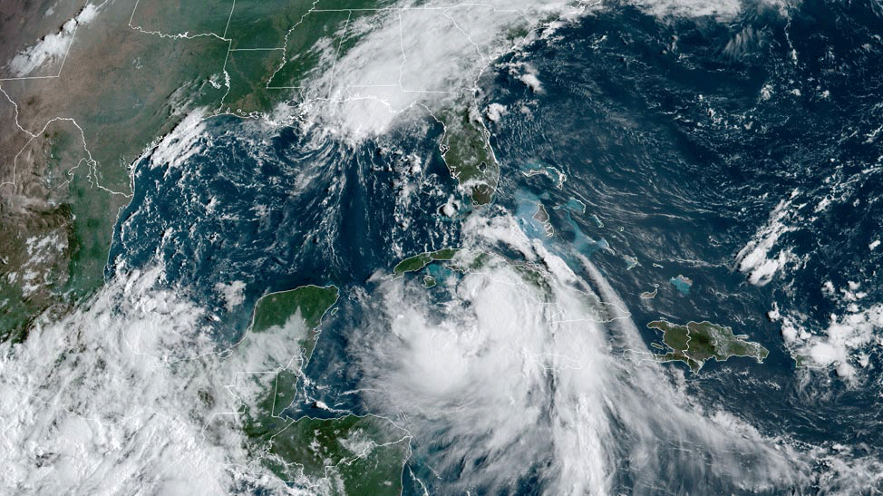
that white mass is laura? jesus she looks like a mean bitch
It's pulled much of Marco into it piece by piece. Eyewall is still recovering from Cuba but it almost appears as 2 massive storms on sat atm.
1598386898610.png
 
  • 2Like
Reactions: 1 users